 Google has a FREE product called Google Earth. It is described as software that "… lets you fly anywhere on Earth to view satellite imagery, maps, terrain, 3D buildings, from galaxies in outer space to the canyons of the ocean. You can explore rich geographical content, save your toured places, and share with others."
It can be downloaded at the following link: http://earth.google.com/ It has more features than the standard Google Maps software. One such feature is the ability to overlay images onto their maps.
In the April 21 log we used land records to map out the location of George Ruth's home in 1910. We even used an 1887 map to plot the location. This time we are going to use our map with the Google Earth Overlay feature. We will use it to see the present day location of George's home.
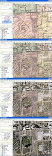
We loaded Google Earth and zoomed in on the West Side of Baltimore's inner-harbor. We selected the "Add Image Overlay" button and added our 1887 map image. The image appears over the Google map with green lines around the edge of our picture. We stretched the green borderlines until our map aligned with the present day image on Google Earth.
I matched the images using the roads to the north, west and southwest of the stadium area. The eastern inner-harbor area has been rejuvenated.
The "Add On Image" dialog box has a slider that adjusts the opacity (See-through ability) of the image. We captured 4 pictures showing the different levels of opacity. The last image shows a modern day picture with a yellow dot marking 406 w Conway Street. When you click on the image to the right a larger image appears. When the larger image appears, click on it again. The image is about 400 Kb in size.
The old map we used was meant to show Baltimore's ward boundaries. In 1887 George's neighborhood was in the 16th ward. The map does not guarantee exact street placement. If we wanted pinpoint accuracy, we could go to city hall and pull up official street maps. Or, we could hire a surveyor, go to Eutaw Street and use the street description document that appeared in the previous post.
Even if the mark on our map is off by 10 or 20 yards, the stadium groundskeepers are not letting us on to the field.
LINKS
http://earth.google.com/
Copyright 2008, 2009 BabeRuthGenealogy
No comments:
Post a Comment